The D&L Blog

Post by: Miranda Waldman, GIS Analyst Intern
My name is Miranda Waldman, and I am a rising senior at Penn State studying Geography. This summer I interned as a GIS Analyst for the D&L. As my internship comes to an end, I am here to give you a look into how I’ve spent my time with the D&L.
We obtained scans from Lehigh University of historic hand drawn maps of the Lehigh Canal from 1864. They are a series of nine maps that show the extension of the Lehigh and Susquehanna Railroad. The chief engineer on the project was John Leisenring. I took these maps and georeferenced them to modern imagery. Georeferencing means that they will line up with their correct location. This process involves selecting points on imagery and the maps that are the same in order to give the old maps spatial information. When sufficient features have been selected the maps will align.
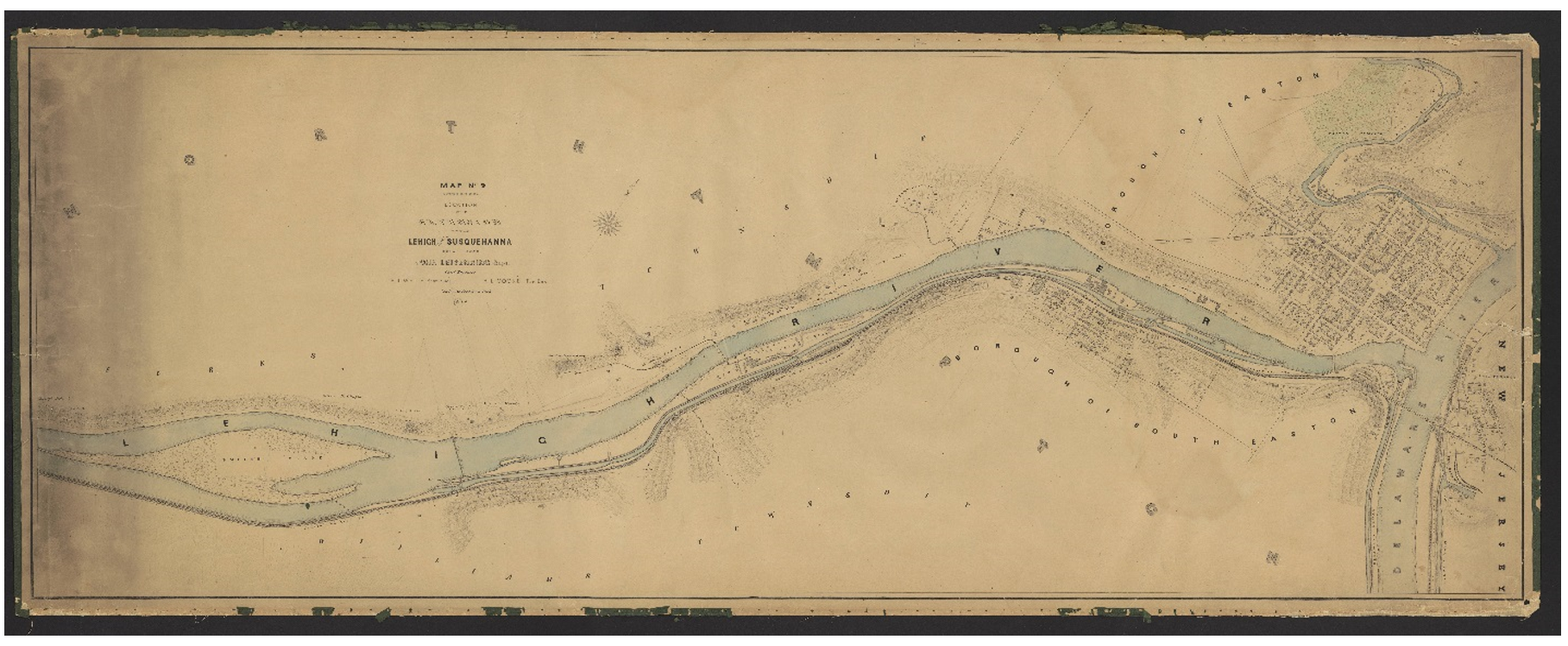
1864 map of Easton, PA.
I created a web app which allows the user to slide between the maps and current imagery, with the D&L Trail on both screens. I love this feature because you can really see how the trail is right next to history.
Check out the Lehigh Canal 1864 Map Viewer for yourself here!
Another task I completed during my time here was making Facebook pages for every D&L Trailhead. Now, each page has the location of the trailhead and the link to our website, with most of the pages having pictures included.
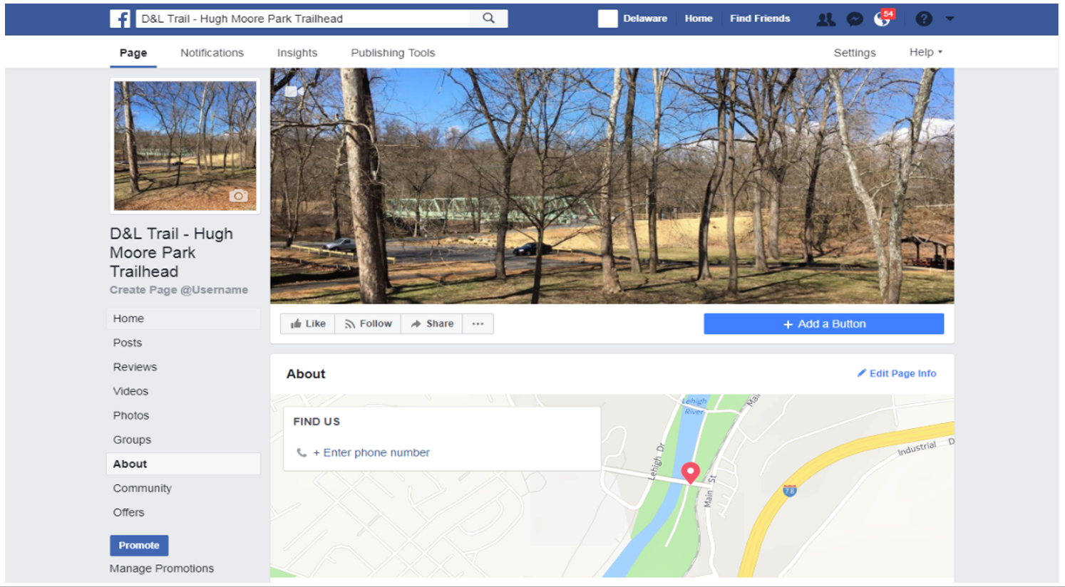
Hugh Moore Park Trailhead Facebook page
When trail users go to the trailheads and check in on Facebook, these new pages will be the place they use. This will make check-ins for the trail consistent and will get the word out about the D&L!
This summer, I also spent time managing our database, which included keeping our online map updated using ArcGIS Online, downloading and organizing imagery for the corridor so that it is all accessible and in the same place.
In addition, I counted how many people were on the trail. We have trail counters at some of our trailheads that count when you guys are using the trail! They need to be calibrated manually because they are not 100% accurate. For example, if two people are walking side by side past the counter, it will count them as one person. That is one of many reasons why we need to calibrate them.
I truly enjoyed my time at the D&L this summer! I have done a lot and will miss this organization when I return to school in the fall.
Archives
- Mar 2024
- Feb 2024
- Jan 2024
- Dec 2023
- Nov 2023
- Oct 2023
- Sep 2023
- Aug 2023
- Jul 2023
- Jun 2023
- May 2023
- Apr 2023
- Mar 2023
- Feb 2023
- Jan 2023
- Dec 2022
- Nov 2022
- Oct 2022
- Sep 2022
- Aug 2022
- Jul 2022
- Jun 2022
- May 2022
- Apr 2022
- Mar 2022
- Feb 2022
- Jan 2022
- Dec 2021
- Nov 2021
- Oct 2021
- Sep 2021
- Aug 2021
- Jul 2021
- Jun 2021
- May 2021
- Apr 2021
- Mar 2021
- Feb 2021
- Jan 2021
- Dec 2020
- Nov 2020
- Oct 2020
- Sep 2020
- Aug 2020
- Jul 2020
- Jun 2020
- May 2020
- Apr 2020
- Mar 2020
- Feb 2020
- Jan 2020
- Dec 2019
- Nov 2019
- Oct 2019
- Sep 2019
- Aug 2019
- Jun 2019
- May 2019
- Apr 2019
- Mar 2019
- Feb 2019
- Jan 2019
- Dec 2018
- Nov 2018
- Oct 2018
- Sep 2018
- Aug 2018
- Jul 2018
- Jun 2018
- May 2018
- Apr 2018
- Mar 2018
- Feb 2018
- Dec 2017
- Nov 2017
- Oct 2017
- Sep 2017
- Aug 2017
- Jul 2017
- Jun 2017
- May 2017
- Apr 2017
- Mar 2017
- Feb 2017
- Jan 2017
- Nov 2016
- Oct 2016
- Sep 2016
- Aug 2016
- Jul 2016
- Jun 2016
- May 2016
- Apr 2016
- Mar 2016
- Feb 2016
- Jan 2016
- Nov 2015
- Oct 2015
- Sep 2015
- Aug 2015
- Sep 2014
- Aug 2014
- Jul 2014
- Jun 2014
- May 2013
- Apr 2013
- Jan 2013
- Oct 2012
- Sep 2012
- Aug 2012
- Jul 2012
- Jun 2012
- May 2012
- Apr 2012
- Mar 2012
- Feb 2012
- Dec 2011
- Nov 2011
- Oct 2011
- Sep 2011
- Aug 2011
- Jul 2011
- Jun 2011
- May 2011
- Apr 2011
- Mar 2011
- Feb 2011
- Jan 2011
- Dec 2010
- Nov 2010
- Oct 2010
- Sep 2010
- Aug 2010
- Jul 2010
- Jun 2010
- May 2010
- Apr 2010
- Mar 2010
- Feb 2010
- Jan 2010
- Dec 2009
- Nov 2009
- Oct 2009
- Sep 2009
- Aug 2009
- Jul 2009
- Jun 2009
- May 2009
- Apr 2009
- Mar 2009
- Feb 2009
- Jan 2009
- Dec 2008
- Nov 2008
- Oct 2008
- Sep 2008
- Aug 2008
- Jul 2008
- Jun 2008
- May 2008
- Apr 2008


