The D&L Blog

By Lauren Golden, Trail & Stewardship Manager

On August 18th, the D&L, North Catasauqua Borough, Lehigh Valley Planning Commission and Northampton and Lehigh Counties came together for a virtual Town Hall to discuss the first projects that will go to construction within the D&L’s Lehigh Valley Gap. During the Town Hall, the D&L and project partners did a deep dive into the project specifics including when trail users might expect shovels in the ground on these first two projects. As I’ve talked extensively before, the D&L’s Lehigh Valley Gap will not be fully connected quickly for both financial and logistical reasons. However, with the progress made as outlined in the town hall, I thought it might be informative to explain how those two projects fit into the overall work towards connecting this big gap.
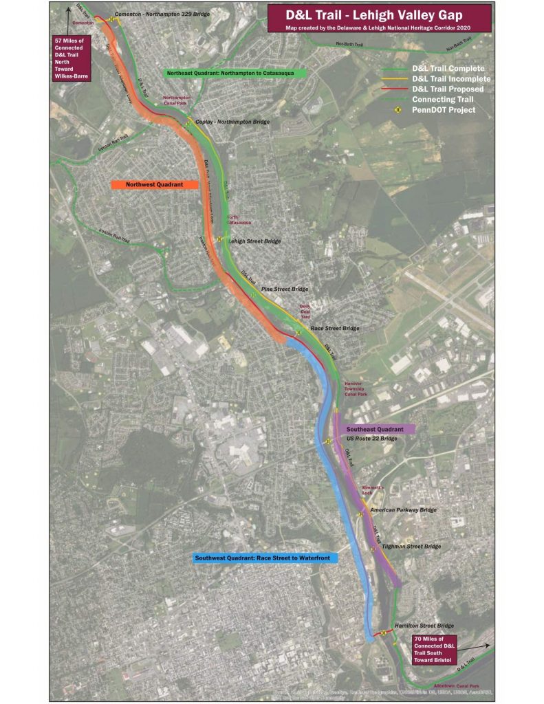
As detailed previously in our blog, “The Next Big Gap” , we’re working towards trail on both sides of the Lehigh River. The Lehigh Valley Planning Commission’s recent Walk/RollLV Plan outlines the ways in which this trail corridor along the river can serve as an integrated part of the transportation system, helping those without cars access employment centers as well as helping to get more than a few cars off the roads. While analyzing this section as a transportation system, the overall goal needed to be broken down. The first way of breaking the gap down was into four quadrants; northeast, southeast, northwest, and southwest. The Race Street Bridge (Catasauqua) forms the boundary between the north and the south and the Lehigh River is the boundary between the east and the west. Another way of breaking down the gap is into the four phases of trail project development; planning, acquisition, engineering, and construction.
Northeast Quadrant: Northampton Borough to Catasauqua Borough
Looking at each quadrant, we’ve determined that the northeast quadrant was the farthest along in both ownership and engineering. The D&L and partners have applied for over $1.3 million in funding to construct 1.5 miles of trail from the downstream side of Northampton Canal Street Park through North Catasauqua to the border of Lehigh County at Catasauqua. This would complete the last missing segment of D&L Trail in Northampton County and create an over 60-mile continuous section of D&L Trail. If we are successful in securing the funding, we hope to begin construction in 2021. You can support this project by contacting local elected officials to encourage that this trail project be funded and built.
From there, connections are a little bit like a game of chess.
Southwest Quadrant: Allentown Waterfront to Race Street Bridge
The southwest quadrant follows the former RJ Corman railroad connecting Allentown’s Waterfront and Buck Boyle Park to the Race Street Bridge and is owned by our trail friendly partners at the Waterfront Development Corporation. This section, having been planned and acquired, is queued up to begin the engineering phase to build a road-with-trail from the Waterfront project (between Tilghman St Bridge and the American Parkway Bridge) northward to about Grape Street, and then trail only from Grape Street north to Race Street. The D&L is actively working with Waterfront Development Corporation, Lehigh County, Lehigh Valley Planning Commission, City of Allentown, Whitehall Township and many other partners to plan how to fund the engineering phase. When the northeast quadrant described above and this quadrant are constructed, we anticipate they will form the first connected D&L Trail route through the Lehigh Valley, eliminating the gap but not completely building out all the potential connections. Just to clarify: the through-route would come from Slatington south to Cementon on the west side of the river, cross the Lehigh River at Route 329 to Northampton, head south to Catasauqua on the east side, cross back to west side of the river using the Race Street bridge, head south to America On Wheels and cross back to the east side of the river using the Hamilton Street bridge, then turn left on Albert Street to go to Allentown’s Lehigh Canal Park and head towards Bethlehem.
Southeast Quadrant: Catasauqua to Allentown Canal Park
The southeast quadrant has some trail in place but like the Northampton and North Catasauqua section, it needs improvements to meet multi-use trail standards (the 10 ft wide trail D&L Trail users are accustomed to in other sections). But at Kimmett’s Lock, the canal basin ends where a guard lock let canal boats into the river. Between Kimmett’s Lock and the Hamilton Street Bridge the towpath no longer exists, having been taken over by active railroad tracks. So, the trail must go on to the roadway somehow. In order to determine the most feasible way to do this safely, the D&L has applied for grants to work with the partners do a trail study of the area. Trail studies are one of the ways to complete the planning phase, where multiple routes are examined and the feasibility of each route is assessed. To date the D&L has received 50% of the necessary funding for this study and we’re hopeful that we’ll be awarded the rest when more grants are announced later in the year. This section of trail presents the opportunity to possibly connect the D&L Trail to Coca-Cola Park, something else we hope to explore further in the trail study, which will take 18 months to complete. From there engineering (and permitting) can begin, so we are some years away from construction in this quadrant.
Northwest Quadrant: Race Street Bridge to Cementon
The northwest quadrant will very likely be the last piece to be completed. This is not for lack of support since this will be the quadrant to connect the D&L Trail to the Ironton Rail-Trail then south to Allentown’s Waterfront, a major connection for THE LINK Trails Network. This former railroad bed north of Race Street in West Catasauqua is still privately owned and Lehigh County is working diligently to acquire this roughly 3.5 miles of former rail bed, but negotiations are often slow going. Even if Lehigh County were to acquire the section tomorrow, a new bridge is still needed to connect the trail at Water Street, just south of the Lehigh Street Bridge (Darktown, Hokendauqua) at a complex intersection where road and railroad both crossed the Coplay Creek as it flows into the Lehigh River. There will also need to be a route determined as the rail bed approaches Cementon and crosses Rt 329. So, at minimum this quadrant will be built with 3 or 4 different construction projects, the details of which will be worked out when we get to the engineering phase. Once the acquisition process is complete, engineers can begin determining the scope of each project, permits necessary, and associated costs. Fortunately, improvements to rail bed are straightforward. Unfortunately, bridge installation is not usually straightforward.
To summarize, there is hope that the D&L’s Lehigh Valley Gap will have a through connection in the near future (5-8 years). Removing the entire trail gap in a way that improves the trail as a transportation network will take more time. A component I have not included are the bridges that connect the two sides of the river. At this time, some bridges are equipped to handle pedestrian traffic while others do not at all and probably will not (Rt 22 for example). Upcoming improvements to the bridges in this section are planned individually to determine if and where improvements can be made in terms of trail connections in addition to vehicular traffic.
We can’t do it alone
The D&L does not do any of this work alone. This project is truly a regional project, with support from two counties, seven municipalities, PennDOT, Lehigh Valley Planning Commission, PA Department of Conservation and Natural Resources, PA Department of Community and Economic Development, elected representatives, and other state and federal agencies. We are grateful to all for their support on this project. The D&L Trail would not exist without their partnership and joint belief that this project will benefit all Lehigh Valley residents, both present and future.
To those of you who use and enjoy the D&L Trail and want to see these projects completed, we need your help. Our biggest project to date, the Mansion House Bridge in Jim Thorpe, was completed in 2019 because the community expressed their support for the project and that’s what we need in the Lehigh Valley. Tell your friends about the trail. Call or write your local elected officials and tell them you want them to support this project. Visit our website to make a donation to the D&L Trail in the Lehigh Valley region. Knowing that so many people are using the D&L Trail to stay healthy and happy during this pandemic has made the whole D&L staff even more proud of the work we do, please help us continue to bring you more miles of trail to enjoy.


