The D&L Blog


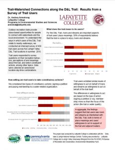
Last summer, Dr. Andrea Armstrong, professor of Environmental Studies & Sciences at Lafayette College, and her EXCEL Scholar Jenna Ellis, conducted a survey of 408 trail users across five Lehigh Valley D&L Trail locations (DL Trail-watershed infosheet FINAL 2018) to understand the ways in which users of the D&L Trail relate to nearby waterways. The findings suggested that trail users see rivers and streams as intertwined with the D&L Trail, both in terms of place meanings and users’ willingness to act in support of the trail and adjacent waters.
What does the trail mean to its users? For the D&L Trail, rivers and streams are important aspects of trail users’ place meanings. 89% of respondents believe that the trail is a place to enjoy rivers and streams. Trail users exhibited similar levels of willingness to act on behalf of rivers and streams as willingness to act on behalf of the trail itself. The differences in willingness to act are based on the type of action (signing a petition or org. membership) more so than the focus of the action (the trail or water quality). Check out the data (DL Trail-watershed infosheet FINAL 2018) to learn more.
It makes sense that users feel connected to the streams because 74% of the D&L Trail is within 200 feet of a stream. All of the Lehigh River Water Trail Access points except for one are also D&L trailheads. So the D&L Trail is literally intertwined with water!
 Another Fun Fact from our data scientist Brian Greene: When the bridge opens up in Jim Thorpe, there will be 6 bridge crossings of the Lehigh River along the D&L Trail and there are 6 bridge crossings of the Delaware River that are part of the D&L / D&R loop trails. What a great ways to see the rivers!
This project was conducted by Lafayette College in collaboration with the Delaware & Lehigh National Heritage Corridor. Funding was provided by Lafayette College and a Lehigh Valley Greenways Minigrant from the PA DCNR, PA Bureau of Recreation and Conservation, Environmental Stewardship Fund.


