The D&L Blog


Scattered across the Delaware and Lehigh River Valleys are mysterious stone structures whose origins remain blurred by time. From crumbling walls deep in the woods to carefully stacked formations tucked along old industrial corridors, these stoneworks have sparked curiosity among hikers, historians, and locals for generations. In this exploration, we dive into the legends, the possibilities, and the unanswered questions surrounding these enigmatic remnants—inviting readers to look closer at the landscape they thought they knew.
The Mysterious Stoneworks of the Delaware & Lehigh River Valleys
Jim Wilson, PA Chapter Member, New England Antiquities Research Association
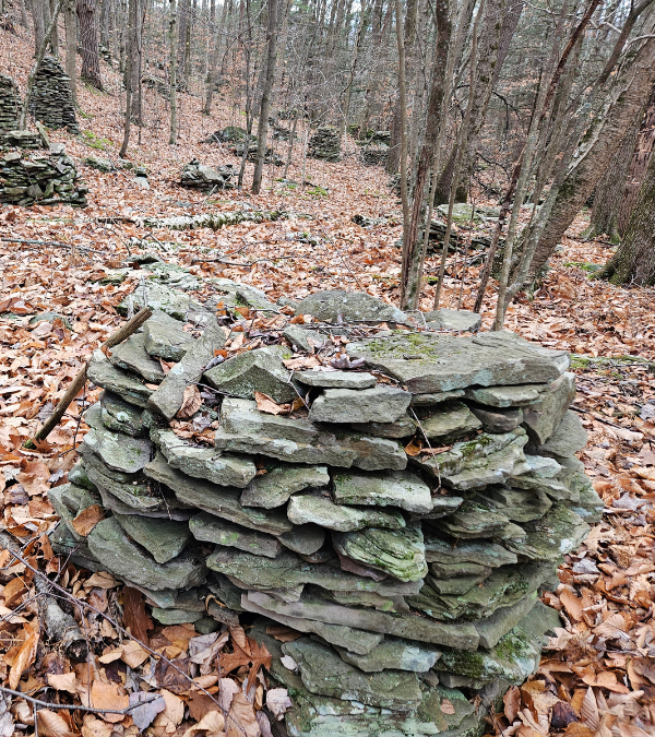
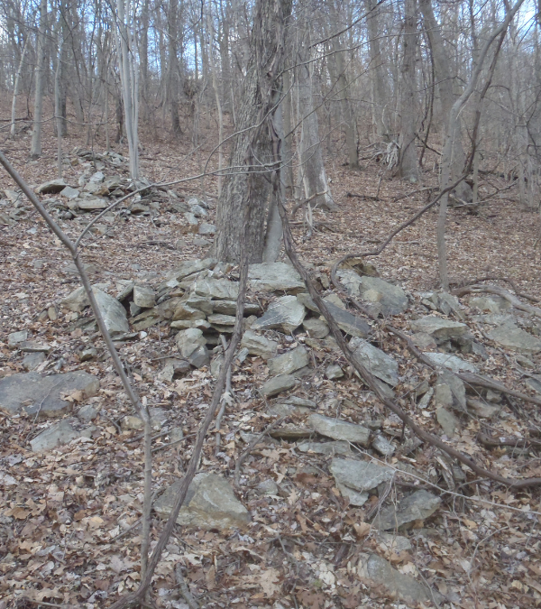
Like rural landscapes in many places across Pennsylvania, those that encompass the five counties that make up the D&L National Heritage Corridor can sometimes be found peppered with manmade stoneworks. Stone rows, stone walls, piles of stacked stones in woodlands, wetlands and on hillslopes and mountainsides. Some beautifully constructed and others seemingly thrown together. Many if not most of these stoneworks are arguably the handiwork of European settlers, early American farmers and others who cleared the land to build farmsteads, industries and communities. However, not all of these dry laid stone constructions fit that early Euro-American land use paradigm.
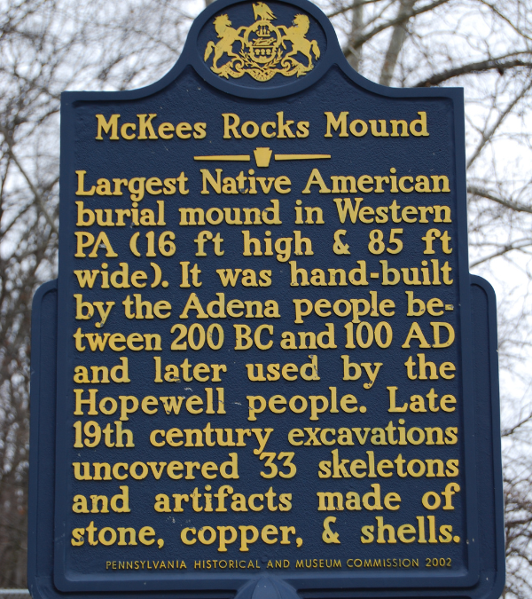
Since the mid-20th century, mainstream archaeology would have us believe that Indigenous peoples who lived in what is today Pennsylvania—or most anywhere in the mid-Atlantic or Northeast—did not practice a stone building tradition of any kind, other than the manufacture of stone tools and implements. In other words, aboriginal peoples who lived here for many thousands of years did not—during all that time— build mounds of earth or stack piles of stones on the landscape, like aboriginal peoples did everywhere else in North America and around the world, albeit for reasons mostly unknown to us today. Think of the countless stacked stone cairns across the American West, the miles of ambiguous stone walls high in the Rocky Mountains, large constructed stone landmarks across the Arctic, massive earthworks and earthen mounds of various shapes and sizes in the Southeast and Midwest, and stoneworks and stone mounds throughout the Upper Ohio River Valley, some as close as western PA. And every one of these features are recognized by archaeologists as Native American made landscape constructions. It would seem shortsighted to assume that Indigenous peoples in the Northeast did not practice a similar constructed stone landscape tradition over the 12,000+ years they lived here.
Early antiquarians and archaeologists didn’t always dismiss Native Americans as having built stone structures in Pennsylvania, however. In his 1928 book, A History of the Indian Villages & Place Names in Pennsylvania, prominent scholar and Native American historian, Dr. George P. Donehoo includes an appendix titled Prehistoric Works in Pennsylvania. In that supplement, Donehoo cites primary source references to literally hundreds of dry laid Indigenous built stone structures from 32 of Pennsylvania’s 67 counties, including Luzerne, Northampton and Bucks in the D&L Corridor. These structures are variously referred to in the literature as stone mounds, stone piles, stone heaps, stone pyramids, stone inclosures, stone forts, stone cists, stone graves, stone rows and stone walls. Many of these source references were cited by Donehoo from the Catalog of Prehistoric Works East of the Rocky Mountains by American ethnologist, Cyrus Thomas and published in 1891 as Bulletin Number 12 by the Bureau of Ethnology.
When and why the paradigm shifted from archaeology and the early cultural resource management community recognizing that Indigenous Pennsylvanian’s built stone structures on the landscape as part of a cultural tradition to asserting that they did no such thing, isn’t exactly known. But by the mid-20th century, it had already happened.
Rock piles, stone mounds, stone walls and other rock constructions are some of the most ambiguous yet common archaeological features found on landscapes around the world. They can appear to be consistent with many different interpretations, from prehistoric burials to colonial farming practices to modern day land clearing. Constructed stone features have always been a hot topic in American archaeology, but they have never been treated as a standard archaeological site type and have, unfortunately, been mostly ignored by archaeologists and the cultural resource management community.
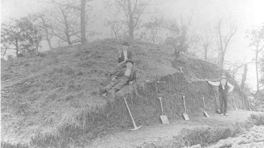
Nineteenth and early 20th century archaeologists in the Upper Ohio Valley conducted many investigations of Native American stone piles or mounds. In most cases, these features, when excavated, contained no artifacts of any kind, leading those researchers to conclude that rock features generally lack cultural significance and research potential. As early as 1897, prolific Ohio Valley archaeologist, Warren Moorehead stated that the scarcity of artifacts associated with small rock piles in particular meant, “It is certain that scientists can learn nothing more from them and further excavation is unnecessary.”
Sixty-three years later, in 1960, prominent Indiana archaeologist and stone mound specialist, James Kellar published a synthesis of the historical research of 83 stone mounds that were excavated in the 19th and early 20th centuries, including 20 in western Pennsylvania. In an insightful and relevant chapter titled The Stone Mound Problem, he discusses the often poor excavation techniques and reporting done by those early archaeologists, their various attempts to categorize and date rock features based on folklore or gross analogy, and their widely differing interpretations of the meanings of the stoneworks. Kellar also lamented the fact that stone features weren’t being taken more seriously by archaeologists and the cultural resource management community in his day.
To this day, the subject of constructed stone features as archaeological landscape artifacts in the Northeast is generally not addressed in anthropology or archaeology programs in colleges or universities. And archaeologists and cultural resource managers today are generally unfamiliar with how to identify, record and interpret constructed stone features. They often assume they are historic and believe that historic rock features lack cultural significance and research potential. Sixty-six years after he wrote The Stone Mound Problem, our understanding of constructed rock features has not significantly progressed beyond Kellar’s 1960 publication. Until recently, that is. As once again, the proverbial paradigm is shifting. This time, thanks to the science of luminescence dating, the efforts of a citizen science group collaborating with archaeologists and—oddly enough—the natural gas pipeline industry.
In the early 2000s, following pioneering advancements in horizontal drilling and hydraulic fracturing for underground natural gas reserves in southwestern Pennsylvania and across the northern tier, widespread leasing and drilling began, leading to major pipeline infrastructure expansions to transport the vast quantities of gas to East Coast refineries and markets. These federally funded and regulated projects require archaeological surveys of proposed pipeline routes to identify any archaeological or historic resources within or near the proposed pipeline right-of-way. By federal law, such resources encountered along the survey route must be reported to the State Historic Preservation Office in the state where they were found. In 2012, during an archaeological survey of a 125-mile-long proposed pipeline from Susquehanna County, PA to Schoharie County, NY, nearly 300 anomalous piles of intentionally stacked stones of similar shape and morphology were found at 60 sites in five New York and Pennsylvania counties along the survey route, mostly on wooded hillsides and hilltops.
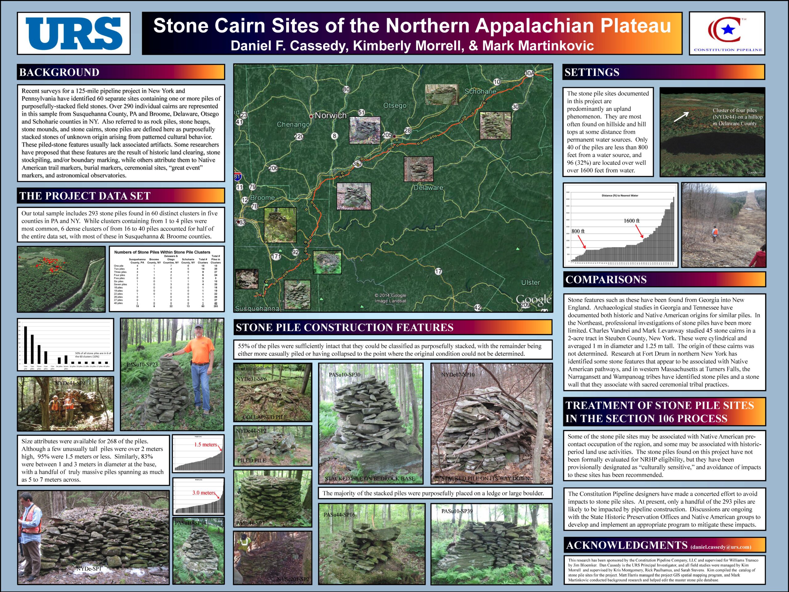
Unsure of their origin, but still recognizing the potential cultural significance of these stone features, whether prehistoric or historic, the project archaeologist termed them “culturally sensitive” in their reporting of them to the Pennsylvania and New York State Historic Preservation Offices. In an infographic the archaeological consulting firm produced about these constructed stone piles, they mention how similar stone features in the Southeast and Northeast have been documented as having prehistoric origins and that these 300 stone piles may be associated with Native American precontact occupation of the area. The consulting firm defined these constructed stone features as, “purposefully stacked stones of unknown origin arising from a patterned cultural behavior.” These mysterious, possibly Indigenous-made landscape-scale stoneworks are now on the radar of the Pennsylvania State Historic Preservation Office (PA SHPO).
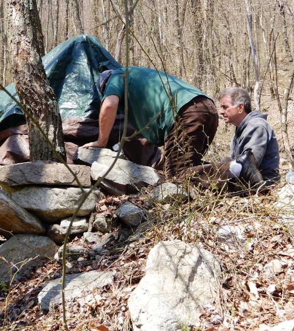
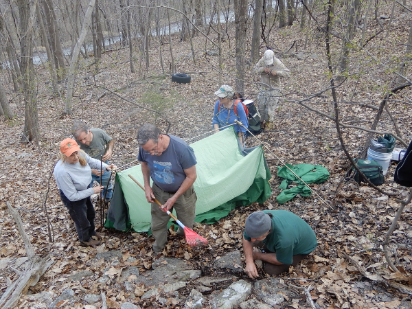
Then, starting in 2020, the New England Antiquities Research Association (NEARA), whose outreach includes the mid-Atlantic and Atlantic Canada, began to collaborate with PA SHPO on documenting and recording anomalous stoneworks in the state’s historic and archaeological sites database, where these site reports are archived and made available for future study. NEARA is a nonprofit organization whose mission is to promote research into the origins and functions of these enigmatic constructed stone landscapes throughout northeastern North America. PA SHPO is the official historic preservation agency for the Commonwealth of Pennsylvania. Since 2020, this partnership has visited, documented and recorded constructed stone sites in Berks, Northampton, Monroe, Pike and Luzerne Counties. And they continue to work together to field view and document sites, including stonework sites in the D&L Corridor.
Since 2018 and in an effort to put science to work and prove some of these structures predate European contact, NEARA has paid for the dating of dozens of stone structures from many sites throughout the Northeast, including a number of sites in the greater Lehigh Valley and D&L Corridor. Luminescence dating is a well-established and scientifically proven methodology for determining how long ago mineral grains were last exposed to sunlight or sufficient heating. It is useful to geologists and archaeologists who want to know when such an event occurred; like when a stone feature was constructed. By carefully collecting a stone under night-vision conditions from within the feature and analyzing it in a luminescence lab, archaeologists can tell how long ago that stone last saw daylight and by extension, when that stone structure was built.
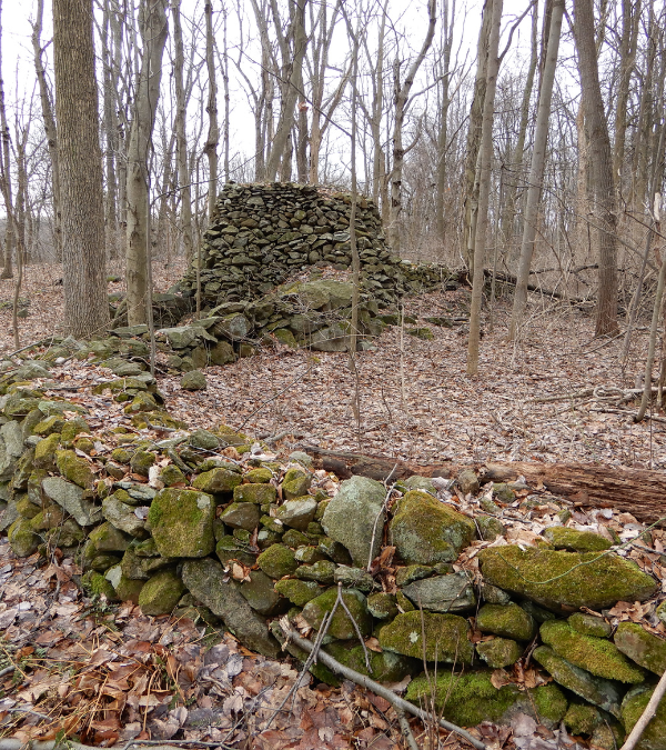
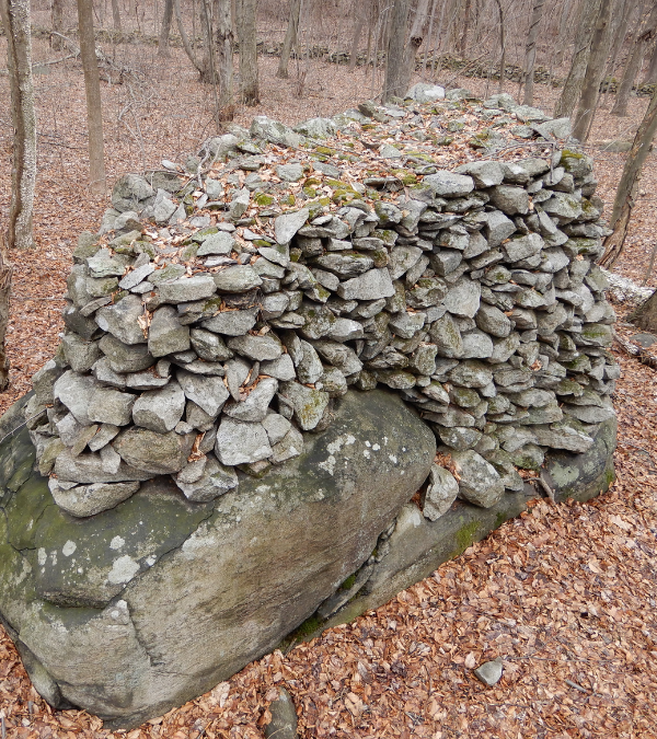
In 2018 and 2021, constructed stone features in Berks, Northampton and Luzerne counties were dated via luminescence archaeology. Stone samples collected from these features and analyzed in the Luminescence Dating Lab at the University of Washington in Seattle revealed approximate construction dates that ranged from 560 BC to 1730 AD. With just one exception, the construction dates for these sites all predate European settlement of the region. These sites include Council Rocks in Luzerne County; the Smith Gap Cairns, Berlin Walls and Hexenkopf Wall in Northampton County; and the Oley Hills Site in Berks County.
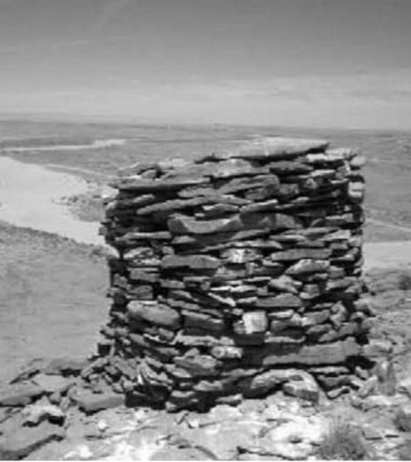
The 11-acre Oley Hills Site contains well over 100 stone features, including some of the largest and most beautifully constructed and well-preserved monumental stoneworks found anywhere in the Northeast. While located just outside the Lehigh Valley in eastern Berks County, the Oley Hills Site is situated in the Little Lehigh Creek Watershed, which is part of the Lehigh River Watershed and the greater Lehigh Valley and Delaware River Basin. The site dates to about 560 BC and was written about here by the archaeologist who conducted luminescence dating of stone samples collected from the site in 2018, and here by the PA SHPO Archaeologist who visited and recorded the site in the agencies historical and archaeological sites database in 2020.
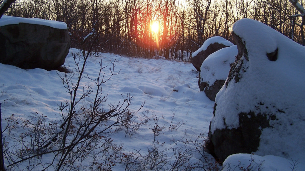
The other local sites at which stoneworks were dated using luminescence science are located in Luzerne and Northampton Counties, which are both in the D&L Corridor. Council Rocks is situated on private property high on Council Rock Mountain overlooking the Susquehanna River Valley in Bear Creek Township, Luzerne County. Stone features at this site include four enormous boulders, a rockshelter and a number of other constructed stoneworks that date from 300 BC to 550 AD. Solstice and equinox alignments are well documented at the site, which is believed to have been a Native American archeoastronomy site. This site was recorded with PA SHPO in 2011.
Two of the three stonework sites in Northampton County are located on the steep rocky slopes of Blue Mountain. The Berlin Walls was first recorded in 1887 by local avocational archaeologist, Alfred Berlin as a “game drive” built by Indians (A Game Drive, Berlin, A.F., The American Antiquarian and Oriental Journal, (1880-1914); Sep. 1887). Berlin describes the site as, “an ancient structure, irregularly thrown together, and varying in height from one to three feet.” He further describes the walls as being about one mile long, extending from near the summit of Blue Mountain down into the Lehigh Valley below.
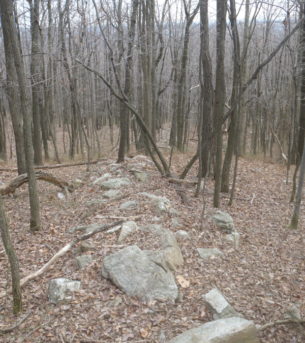
Today, only about 1300 linear feet of the uppermost reaches of the walls remain intact on the steep rocky slopes of State Game Lands 168 in Lehigh Township, where they are protected from development on public land. The lower reaches of the walls in the valley below were destroyed in late 19th and 20th century land clearing for farms, roads, utility lines and residential communities. This site was officially recorded in PA SHPO’s archaeological sites database in 2022. In 2021, one of the walls was dated through luminescence lab analysis to about 1500 AD.
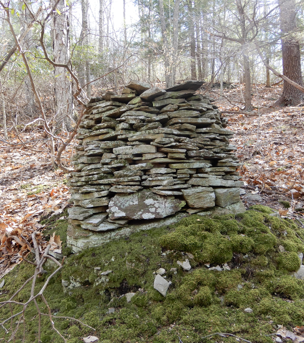
The other site on the steep slopes of Blue Mountain in Northampton County is also located on State Game Lands 168. Here, 21 low crudely assembled, flat-topped stone piles or cairns occupy about one acre of steep rocky mountainside in Moore Township. These cairns are all constructed on top of large talus boulders or outcrops of bedrock and appear to be constructed in rows roughly equidistant from each other, both vertically and horizontally on the steep rocky mountainside. A perennial mountainside spring is located just downslope of the cairns.
This one-acre cairn field on steep wooded slopes is also located within 100 feet of Smith Gap Road, an unpaved public roadway which is recorded as having been constructed along the Wechquetank Path, where it climbed up and over Blue Mountain through Smith Gap, between today’s Northampton and Monroe Counties. The Wequetank Path is a recorded Indian trail that led from the Lehigh Valley in Northampton County north to the Wyoming Valley in Luzerne County (Indian Paths of Pennsylvania, Pennsylvania Historical & Museum Commission, Paul A. W. Wallace, 1965). Situated on a steep rocky mountainside next to a recorded Native American footpath, the Smith Gap Cairns were also added to the PA archaeological sites database by PA SHPO in 2022. In 2021 one of the cairns here was dated via luminescence lab analysis to about 1730 AD.
The third Northampton County site from which stone samples were collected for luminescence lab analysis, is an ambiguous stone wall on private property on Hexenkopf Ridge in Williams Township. Unfortunately, the luminescence lab analysis of these stone samples was inconclusive. However, an 1877 sketch map of Hexenkopf Ridge, by George Laubach of Durham and in the collections of the Bucks County Historical Society, depicts and labels “Indian walls” and “Indian mounds” on the map at about the same location where stone walls and stacked stone mounds can be found on the landscape today.
Today, citizen science volunteers with NEARA and archaeology staff with PA SHPO continue to work together to visit, map, describe and record these anomalous constructed stone landscapes in PA SHPO’s archaeological sites database so that we can begin to understand their presence in Pennsylvania, regardless of their age or who built them. We have invited the federally recognized Delaware Nation to join us in in these efforts, as many of these stoneworks have been recorded in the past as having been constructed by Native Americans (see Donehoo, Prehistoric Works in Pennsylvania, above). The Delaware Nation in Anadarko, Oklahoma, on whose ancestral homeland we live in the Delaware River Basin today, established a Tribal Historic Preservation Office (THPO) in the Lehigh Valley in 2020. We look forward to working with the eastern office of the Delaware Nation THPO in our research and study of constructed stone landscapes.
It’s always a fun and exciting day afield with PA SHPO archaeologists exploring, discussing, puzzling over and documenting these enigmatic stoneworks in local woodlands and wetlands here in the D&L Corridor and across eastern PA. I thank PA SHPO for its willingness to take an open-minded look at these ambiguous constructed stone landscapes, and for beginning to record more of them in the agencies archaeological site files as landscape artifacts worthy of recognition and cultural resource management.
Archives
- Mar 2026
- Feb 2026
- Jan 2026
- Dec 2025
- Nov 2025
- Oct 2025
- Sep 2025
- Aug 2025
- Jul 2025
- Jun 2025
- May 2025
- Apr 2025
- Mar 2025
- Feb 2025
- Dec 2024
- Nov 2024
- Oct 2024
- Sep 2024
- Aug 2024
- Jul 2024
- Jun 2024
- May 2024
- Apr 2024
- Mar 2024
- Feb 2024
- Jan 2024
- Dec 2023
- Nov 2023
- Oct 2023
- Sep 2023
- Aug 2023
- Jul 2023
- Jun 2023
- May 2023
- Apr 2023
- Mar 2023
- Feb 2023
- Jan 2023
- Dec 2022
- Nov 2022
- Oct 2022
- Sep 2022
- Aug 2022
- Jul 2022
- Jun 2022
- May 2022
- Apr 2022
- Mar 2022
- Feb 2022
- Jan 2022
- Dec 2021
- Nov 2021
- Oct 2021
- Sep 2021
- Aug 2021
- Jul 2021
- Jun 2021
- May 2021
- Apr 2021
- Mar 2021
- Feb 2021
- Jan 2021
- Dec 2020
- Nov 2020
- Oct 2020
- Sep 2020
- Aug 2020
- Jul 2020
- Jun 2020
- May 2020
- Apr 2020
- Mar 2020
- Feb 2020
- Jan 2020
- Dec 2019
- Nov 2019
- Oct 2019
- Sep 2019
- Aug 2019
- Jun 2019
- May 2019
- Apr 2019
- Mar 2019
- Feb 2019
- Jan 2019
- Dec 2018
- Nov 2018
- Oct 2018
- Sep 2018
- Aug 2018
- Jul 2018
- Jun 2018
- May 2018
- Apr 2018
- Mar 2018
- Feb 2018
- Dec 2017
- Nov 2017
- Oct 2017
- Sep 2017
- Aug 2017
- Jul 2017
- Jun 2017
- May 2017
- Apr 2017
- Mar 2017
- Feb 2017
- Jan 2017
- Nov 2016
- Oct 2016
- Sep 2016
- Aug 2016
- Jul 2016
- Jun 2016
- May 2016
- Apr 2016
- Mar 2016
- Feb 2016
- Jan 2016
- Nov 2015
- Oct 2015
- Sep 2015
- Aug 2015
- Sep 2014
- Aug 2014
- Jul 2014
- Jun 2014
- May 2013
- Apr 2013
- Jan 2013
- Oct 2012
- Sep 2012
- Aug 2012
- Jul 2012
- Jun 2012
- May 2012
- Apr 2012
- Mar 2012
- Feb 2012
- Dec 2011
- Nov 2011
- Oct 2011
- Sep 2011
- Aug 2011
- Jul 2011
- Jun 2011
- May 2011
- Apr 2011
- Mar 2011
- Feb 2011
- Jan 2011
- Dec 2010
- Nov 2010
- Oct 2010
- Sep 2010
- Aug 2010
- Jul 2010
- Jun 2010
- May 2010
- Apr 2010
- Mar 2010
- Feb 2010
- Jan 2010
- Dec 2009
- Nov 2009
- Oct 2009
- Sep 2009
- Aug 2009
- Jul 2009
- Jun 2009
- May 2009
- Apr 2009
- Mar 2009
- Feb 2009
- Jan 2009
- Dec 2008
- Nov 2008
- Oct 2008
- Sep 2008
- Aug 2008
- Jul 2008
- Jun 2008
- May 2008
- Apr 2008


