The D&L Blog

By Brian Greene, Director of Trails & Conservation
With the cooler fall weather, it is a great time to get out and explore the D&L Trail. I’m getting phone calls and emails from people near and far planning trips on the D&L Trail. While I like chatting on the phone or answering emails about this world class recreation trail that is near and dear to my heart, sometimes I’m a little busy doing projects on the trail.
So, I’ve spent a lot of time recently to make sure that all the information and insights that you need to plan a trip are available for anyone to use 24 hours a day through our website. I’m going to review 4 of them and give you a preview of an exciting new one that will come out shortly.
Check out our maps

Two of our most popular items that the D&L makes are maps. We have our three different regional trail maps that are great for learning more about the regions and navigating the trail. Recently we worked with our cartographer, Offthemaps, and redesigned all three of the maps at the same time. This allowed us to standardize things across all three maps so they have consistent data, labeling, and information. You can download these maps as PDFs or pick-up a printed copy at our offices, many trail friendly businesses, partner offices, or some trailheads.
These maps are great to have on hand as you walk, run, or bike the D&L Trail. And their online companion is our interactive D&L Trail web map. Once you print a map, it’s hard to change it, so the online web map is where you can go to check current conditions and get the latest updates on all the sections. It’s good to check it before you head out on a trip. And many people do as it is our most visited page on the D&L website.
Get turn by turn directions with our ride guides
Are you directionally challenged? Do you get lost even with a map in your hand? Well, you can use our turn by turn GPS routes that will tell you where to turn and when you go the wrong way. We have built dozens of routes, from simple town to town sections to rides that go off the beaten path. We use the app RidewithGPS to do this and it’s a free app that anyone can use for biking, walking or running on the D&L Trail. Or you can download the GPX file and upload it to a bike computer, GPS watch or other GPS enabled device. Visit our organization page to see over 20 different routes with more to come this fall.
Learn about our Trail Friendly Businesses
Another great resource when planning a trip is our D&L Trail Friendly Business webpage. With over 25 food, lodging, gear and wellness shops these businesses are experts at serving trail users and many make for great destinations right off the D&L Trail. Plus, they have the knowledge, services, and amenities that can make your next trip more enjoyable. So make sure to visit them on your next trip on the D&L Trail.
Take a pre-planned trip using a Bikeout guide
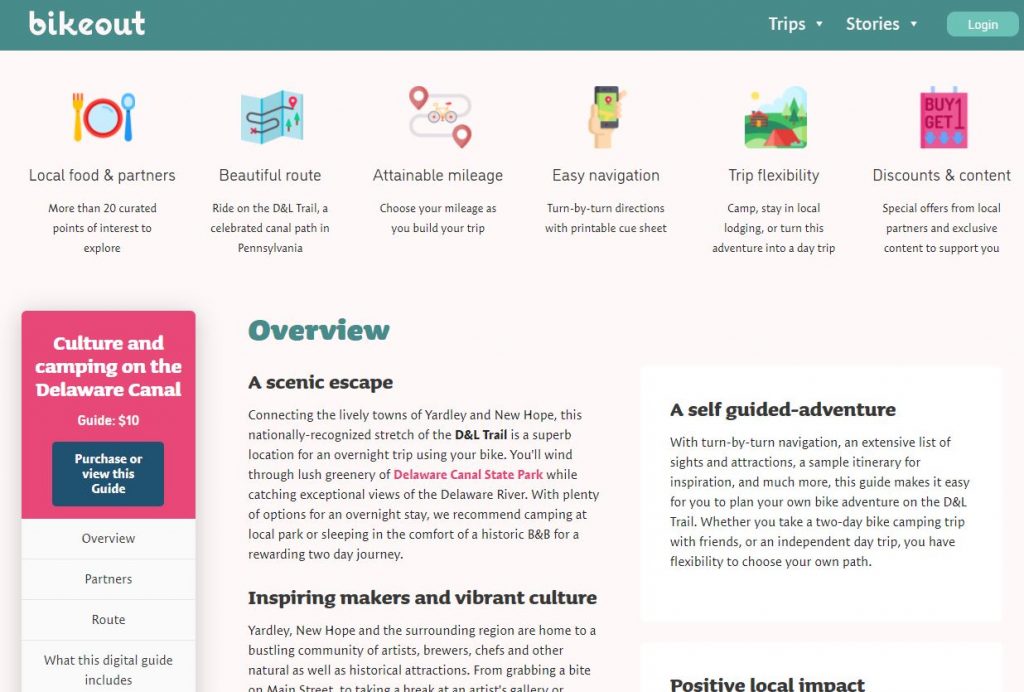
This summer we also worked with Bikeout to help them create three regional curated experiences along the D&L Trail. These choose your own adventure guides highlight the unique sites, businesses, and stories that you can explore along the D&L Trail. So far they have created a guide for the Delaware Canal featuring local artisans and the Lehigh Valley focusing on industrial revitalization. These guides are available for a $10 donation that goes back to support the D&L Trail and provides turn by turn navigation, itineraries, and discounts to local businesses. Plus you can learn more about regions from their great stories like the one about arts around New Hope, Delaware Canal State Park, or industrial revitalization and the D&L. The third guide about the Anthracite Region will come out in late September.
Get ready for the first ever D&L Trail Guidebook
And last, is a teaser of a forth coming project, the first D&L Trail guidebook. We are putting the finishing touches on the guidebook that will help tell the story of the D&L Trail and provide all the information you need to plan a trip for a day or a week on the D&L Trail. At over 100 pages it is filled with maps, historic photos, must see locations, trail friendly business and frequently asked questions. We look forward to using this guidebook to promote the D&L Trail to both residents and visitors alike so the D&L Trail is no longer a hidden gem, but the one of the best trails in America!

