The D&L Blog

From the Trail Manager

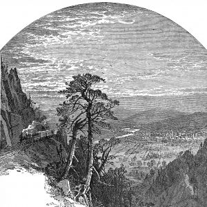
An etching of the panoramic view of Wilkes-Barre and the Wyoming Valley from Penobscot Mountain along the Lehigh Valley Railroad.
For all intents and purposes, the northernmost improved section of the D&L Trail is currently the Black Diamond Trailhead, located on Route 437 near Mountain Top in Luzerne County. The final northern terminus of the D&L Trail, however, is the Susquehanna River. There are about 17 miles between these two points, depending on the final route chosen. In the last few months we’ve seen some fantastic support that will help close this gap that I’m excited to share with you.
If you follow these posts, you’ve heard about the phases of trail development- planning, acquisition, engineering, and construction. Construction is when you can see work happening on the ground, but really the majority of the development work happens long before a shovel ever hits the dirt. This post focuses on the planning work needed in Luzerne County to design and construct this long-awaited trail connection.
Let’s start at the very beginning and further point north: the Susquehanna River. It may sound obvious, but you can’t build a trail until you know where there is room to put it. We are lucky in that the Luzerne/Lackawanna MPO (Municipal Planning Organization) is about to kick off a Bicycle/Pedestrian Study of downtown Wilkes-Barre and Scranton. It will examine the potential routes to connect the Susquehanna River to Laurel Run Borough (where North Branch Land Trust is working diligently on engineering designs). It is the intention of this Study to call out the preferred route in 2019 so we can move into the next phases of trail development.
 Jumping southward, the rail bed segment immediately north of the Black Diamond Trailhead (named for the Black Diamond Railroad that transported coal from the mines along this route) runs through the Glen Summit Community. The residents of this cluster of gorgeous historic houses have asked the D&L to demonstrate how the trail could connect through their community while maintaining the privacy of their residents, and we are happy to oblige. Recently the D&L was awarded two grants to support this project! One from DCNR’s Community Conservation Partnership Program and another from DCED’s Greenways, Trails, and Recreation Grant program.
With these two grants, the D&L will embark on a feasibility study to show potential routes of the trail between the Black Diamond Trailhead and Johnson Street in Penobscot, a roughly 3 mile section. The result of this study will be a route for the trail and associated infrastructure that the Glen Summit community can support, which will enable us to start the design work necessary to go to construction.
If you are a resident or interested trail user/advocate in this area, please keep an eye out for public meetings coming in 2019!


