MENU
  • Trail Heads
  • Town
  • Things to Do
  • Information
  • Reset Map

Trail Sections

Trail Status Key

  • Complete, open and improved
  • Obstruction within trail section, see description
  • Planned Future linkage and trail development
  • Unimproved open, travel at your own risk

Towns

Things to Do

Lansford

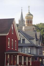
Landmark churches in Lansford, PA, a historic anthracite-mining town along the D&L Corridor

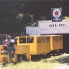
The main attraction in Lansford is the longest operating anthracite coal mine in the world. Today you can ride by rail 1,600 feet underground and take a walking tour of the Number Nine Mine’s innermost workings. While in the deep shaft, originally opened in 1855, you can explore muleways (narrow underground passages connecting different tunnels). You can also view a miner’s hospital room cut in solid stone.

A key point in Lansford’s history occurred in 1870-71, when a railroad tunnel was cut through Nesquehoning Mountain, linking the Panther and Hauto Valleys. This achievement meant coal from Panther Valley could be easily transported by rail to Mauch Chunk through the Hauto Tunnel, without first having to be shipped up the mountain planes via gravity railroad to Summit Hill. This simpler, more efficient transportation link prompted the Lehigh Coal & Navigation Company to move its main offices to Lansford. And wherever the LC&N Co. went, attention followed.

The resulting cultural diversity led to a wide array of landmark churches. The Lansford Historical Society has a self-guided tour available.

Trailheads

No trailheads found.

Things to Do

1

No. 9 Coal Mine & Museum

Ride by rail 1600’ into the earth and tour the No. 9 Mine - the world’s oldest continually operated anthracite coal mine (1855-1972).  In the Mine, visitors get to inspect a 900’ deep mine shaft and see a coal miner’s... More

Get Directions

Thank you for visiting the D&L Trail Interactive Map.

Delaware & Lehigh National Heritage Corridor (DLNHC) is a nonprofit organization that convenes over 30 local landowners that build and maintain the trail from Wilkes-Barre to Bristol.

Please Note: if there is an obstruction within a trail section the entire trail section will be noted as “obstructed”. Be sure to read the description of each trail section to learn the extent of the obstruction and how it may impact your trip. The information on this map is updated with information provided by landowners. An update will remain posted until the landowner confirms it is no longer relevant.

When on the trail you are in a public space and natural area, and you may encounter a range of wildlife, plants, and people. There are unhoused individuals along sections of the D&L Trail that travel through heavily populated areas. The perception of safety is different for each trail user – please stay alert and plan accordingly for your personal comfort level. For more information visit our Plan Your Trip page.

×