MENU
  • Trail Heads
  • Town
  • Things to Do
  • Information
  • Reset Map

Trail Sections

Trail Status Key

  • Complete, open and improved
  • Obstruction within trail section, see description
  • Planned Future linkage and trail development
  • Unimproved open, travel at your own risk

Towns

Things to Do

Riegelsville

One of the few remaining multi-span, highway suspension bridges with continuous cables in Riegelsville, PA.

The village of Riegelsville, a National Historic District, has a fine collection of commercial and residential buildings. Especially impressive are the mansions built by local industrialists.

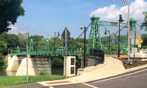
The bridge over the Delaware River here is one of the few remaining multi-span, highway suspension bridges with continuous cables. For comparison sake, consider that the San Francisco-Oakland Bay Bridge has two large back-to-back suspension bridges, but the cables aren’t continuous between the spans.

The existing bridge was built in 1904, as a replacement for the original bridge constructed in 1835. It pulls on anchors attached to each riverbank and was designed by John A. Roebling & Sons of Trenton, New Jersey. The Roeblings are also credited with designing the Brooklyn and Golden Gate bridges, and the aqueduct at Lackawaxen where the Delaware & Hudson Canal crossed the Delaware River between Pennsylvania and New York. For paddlers, Riegelsville has put-in for easy river access. (at River mile 174, above Cooks Creek).

Things to Do

1

Benjamin Riegel House

The Benjamin Riegel House is significant as an excellent example of a vernacular Georgian style house. Riegel, a miller by trade, owned several area mills and was instrumental in the development of both Riegelsville, New Jersey and Riegelsville, Pennsylvania. Riegel... More

Get Directions

Thank you for visiting the D&L Trail Interactive Map.

Delaware & Lehigh National Heritage Corridor (DLNHC) is a nonprofit organization that convenes over 30 local landowners that build and maintain the trail from Wilkes-Barre to Bristol.

Please Note: if there is an obstruction within a trail section the entire trail section will be noted as “obstructed”. Be sure to read the description of each trail section to learn the extent of the obstruction and how it may impact your trip. The information on this map is updated with information provided by landowners. An update will remain posted until the landowner confirms it is no longer relevant.

When on the trail you are in a public space and natural area, and you may encounter a range of wildlife, plants, and people. There are unhoused individuals along sections of the D&L Trail that travel through heavily populated areas. The perception of safety is different for each trail user – please stay alert and plan accordingly for your personal comfort level. For more information visit our Plan Your Trip page.

×