MENU
  • Trail Heads
  • Town
  • Things to Do
  • Information
  • Reset Map

Trail Sections

Trail Status Key

  • Complete, open and improved
  • Obstruction within trail section, see description
  • Planned Future linkage and trail development
  • Unimproved open, travel at your own risk

Towns

Things to Do

Weissport

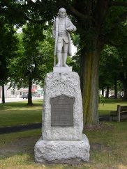
The Fort Allen monument in Weissport, PA, a town with easy access to the D&L Trail

With easy trail access, the little town of Weissport has several claims to fame. First, it’s a great access point for the D&L Trail. Here you can easily slip onto the restored towpath and bike, hike, cross-country ski or fish to your heart’s content. The trail extends north to Jim Thorpe (about 4 miles) and south to Parryville (about 3 miles).

Second, the village sits on the site of the original Fort Allen, which was constructed by Benjamin Franklin and his men in January 1756 in response to a series of Indian attacks. The fort’s original well is a local landmark. Third, Weissport served as a major building site for many of the boats used on the canal. The Lehigh Canal’s 1829 opening greatly influenced the town’s early development, and boat construction began here as early as the 1830s.  Nestled between the Lehigh Canal and River, Weissport has withstood its share of floods over the years. Despite the damaging high waters, many buildings from the early days have survived. So have the tracks for the old Central Railroad of New Jersey, which ran parallel to the canal. The line is still used today as part of the Norfolk Southern Railroad.

Things to Do

1

Beltzville State Park

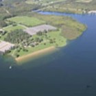
Located in Carbon County, the 2,972-acre Beltzville State Park is developed around the U.S. Army Corps of Engineers flood control project - Beltzville Dam. Beltzville Lake is 949 acres with a shoreline of 19.8 miles. The park is located along... More

Get Directions

Thank you for visiting the D&L Trail Interactive Map.

Delaware & Lehigh National Heritage Corridor (DLNHC) is a nonprofit organization that convenes over 30 local landowners that build and maintain the trail from Wilkes-Barre to Bristol.

Please Note: if there is an obstruction within a trail section the entire trail section will be noted as “obstructed”. Be sure to read the description of each trail section to learn the extent of the obstruction and how it may impact your trip. The information on this map is updated with information provided by landowners. An update will remain posted until the landowner confirms it is no longer relevant.

When on the trail you are in a public space and natural area, and you may encounter a range of wildlife, plants, and people. There are unhoused individuals along sections of the D&L Trail that travel through heavily populated areas. The perception of safety is different for each trail user – please stay alert and plan accordingly for your personal comfort level. For more information visit our Plan Your Trip page.

×