This is an unimproved section of trail. Caution: Trail users interested in long distance trips will need to share the road along North Dauphin Street from Hanover Township Canal Park to Kimmett’s Lock.
Parking remains open at both Hanover Township Canal Park and the Kimmett’s Lock Trailhead.
________________________
UPDATED – March, 2025
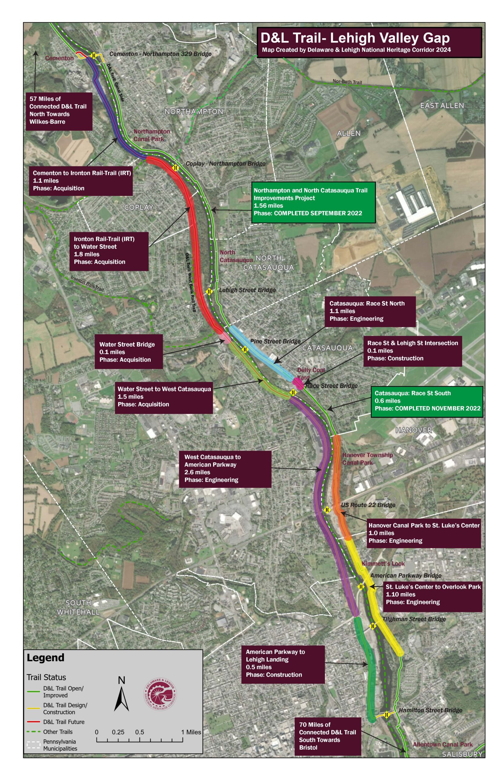
This trail section is part of the D&L Trail Lehigh Valley Gap. This gap includes 10 projects and when complete will span a 14-mile loop with rail trail on the western side and canal towpath trail on the eastern side of the Lehigh River between the Cementon 329 Bridge and the Hamilton Street Bridge. The below trail gap projects are located along this trail section.
Hanover Canal Park to St. Luke’s Way – Engineering
The towpath along Dauphin Street is no longer extant. A feasible route to connect the D&L Trail through Hanover Township was identified in the 2022 Allentown Area Trail Study. Hanover Township is engineering this 0.9 mile section that will extend the length of the municipality through Hanover Canal Park to the municipal border with the City of Allentown near St. Luke’s Way. Construction for the 10-foot wide multiuse path is anticipated in Fall of 2025 with the trail opening to the public in 2026. Funding support for this project comes from the PA Department of Conservation and Natural Resources (DCNR) and PA Department of Community and Economic Development (DCED).
St. Luke’s Way to Overlook Park – Engineering
This trail section is immediately adjacent to the Hanover Township trail section and was also identified in the 2022 Allentown Area Trail Study. The City of Allentown is engineering this 1-mile section that will complete the D&L Trail through Allentown’s East Ward between St. Luke’s Way, through Kimmett’s Lock Trailhead, to the existing trail on Bradford Street just north of Allentown’s Canal Park. Construction of this multiuse and shared use path is anticipated in Fall of 2025 with the trail opening to the public in 2026. Funding support for this project comes from the PA Department of Conservation and Natural Resources (DCNR), PA Department of Community and Economic Development (DCED) and the City of Allentown.

________________________
The Kimmett’s Lock Trailhead is also a Lehigh River Water Trail access point. Please refer to Wildlands Conservancy’s Lehigh River Water Trail website for more information on trips along the water trail.