MENU
  • Trail Heads
  • Town
  • Things to Do
  • Information
  • Reset Map

Trail Sections

Trail Status Key

  • Complete, open and improved
  • Obstruction within trail section, see description
  • Planned Future linkage and trail development
  • Unimproved open, travel at your own risk

Towns

Things to Do

Freemansburg

Freemansburg, a town along the D&L revitalized by volunteers

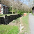
To see what a difference dedicated volunteers can make, head to Freemansburg. Members of the Old Freemansburg Association (OFA) reclaimed their portion of Lehigh Canal from overgrowth and debris, and restored the towpath (D&L Trail). The Borough owns a 1.5-mile section of the Lehigh Canal and towpath, and the OFA spearheaded efforts to protect and restore the 1829 Locktender’s House, mule barn, Lock No. 44, gristmill, and coal yard. Volunteers also reconstructed the barn using canal era tools and equipment–part of the reason it took 10 years to complete the project. The multi-functional building now hosts weddings, educational sessions and interpretative demonstrations.

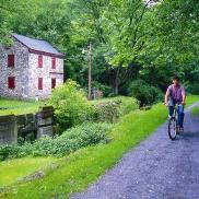
Freemansburg is a classic example of a canal town. Houses and other structures are built up against the waterway that was the village’s lifeblood in the 1800s.

Parking is available at the trailhead near the intersection of Main and Monroe Streets.

Things to Do

1

Freemansburg Canal Education Center

The Delaware & Lehigh National Heritage Corridor, the Borough of Freemansburg, and the Bethlehem Area School District partnered to create the Freemansburg Canal Education Center (FCEC) at the Lock 44 canal complex in Freemansburg. The Delaware & Lehigh National Heritage... More

Get Directions

Thank you for visiting the D&L Trail Interactive Map.

Delaware & Lehigh National Heritage Corridor (DLNHC) is a nonprofit organization that convenes over 30 local landowners that build and maintain the trail from Wilkes-Barre to Bristol.

Please Note: if there is an obstruction within a trail section the entire trail section will be noted as “obstructed”. Be sure to read the description of each trail section to learn the extent of the obstruction and how it may impact your trip. The information on this map is updated with information provided by landowners. An update will remain posted until the landowner confirms it is no longer relevant.

When on the trail you are in a public space and natural area, and you may encounter a range of wildlife, plants, and people. There are unhoused individuals along sections of the D&L Trail that travel through heavily populated areas. The perception of safety is different for each trail user – please stay alert and plan accordingly for your personal comfort level. For more information visit our Plan Your Trip page.

×