MENU
  • Trail Heads
  • Town
  • Things to Do
  • Information
  • Reset Map

Trail Sections

Trail Status Key

  • Complete, open and improved
  • Obstruction within trail section, see description
  • Planned Future linkage and trail development
  • Unimproved open, travel at your own risk

Towns

Things to Do

Upper Black Eddy

Upper Black Eddy, PA, along the D&L Trail

Upper Black Eddy has its origins from the Black family who operated a hotel at there and shares part of its name with the former village of Lower Black Eddy, now known as Point Pleasant. Most of this village’s growth in the early 19th century was due to the opening of the Delaware Canal. As a result, canal-related businesses sprung up quickly, including a shipyard, mule stables, general store and several hotels.

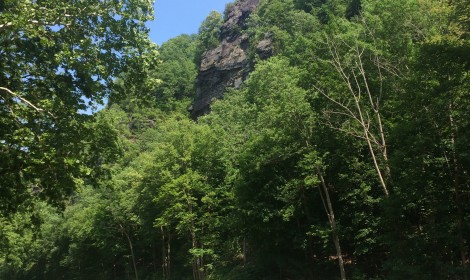
Upper Black Eddy also has two notable geographic features. The first is Ringing Rocks Park, a 4 acre boulder field of Diabase rocks, which “ring” like a bell when struck with a hammer. This park also includes Buck County’s highest waterfall situated on High Rocks Creek. The second is Nockamixon Cliffs, a 400 foot wall of shale overlooking the Delaware River that is located within the Delaware Canal State Park.

Things to Do

1

Delaware Canal State Park

The Delaware Canal is the only remaining continuously intact canal of the great towpath canal building era of the early and mid-19th century. Mule- drawn canal boat rides and the Lock Tender’s House Visitor Center are at New Hope. Paralleling... More

Get Directions
2

Nockamixon Cliffs

The dramatic 300-foot cliffs rise above the Delaware River along upper Bucks County’s scenic River Road. Habitat for an arctic-alpine plant community, rare in both Pennsylvania and in the continental United States, Nockamixon Cliffs also provides scenic beauty as ice... More

Get Directions

Thank you for visiting the D&L Trail Interactive Map.

Delaware & Lehigh National Heritage Corridor (DLNHC) is a nonprofit organization that convenes over 30 local landowners that build and maintain the trail from Wilkes-Barre to Bristol.

Please Note: if there is an obstruction within a trail section the entire trail section will be noted as “obstructed”. Be sure to read the description of each trail section to learn the extent of the obstruction and how it may impact your trip. The information on this map is updated with information provided by landowners. An update will remain posted until the landowner confirms it is no longer relevant.

When on the trail you are in a public space and natural area, and you may encounter a range of wildlife, plants, and people. There are unhoused individuals along sections of the D&L Trail that travel through heavily populated areas. The perception of safety is different for each trail user – please stay alert and plan accordingly for your personal comfort level. For more information visit our Plan Your Trip page.

×